
Our Office
Holt Hall, Rooms 138, 141, 157
530-898-5205
jrotnem@csuchico.edu
Regular Hours
8 a.m.–5 p.m. (Monday–Friday)
Mailing Address
Center for Water & the Environment
400 W. First St.
Chico, CA 95929–0555
Lower Tuscan Aquifer
Lower Tuscan Aquifer Study: Hydrostratigraphy and Pump-test Analysis of the Lower Tuscan/Tehama Aquifer, Northern Sacramento Valley, CA
By Dr. Todd J. Greene, CWE Faculty Associate & Professor in Dept of Geological and Environmental Sciences and Dr. Karin Hoover, Professor in Department of Geological and Environmental Sciences
Thanks to a $50,000 litigation settlement awarded to the CSU, Chico Research Foundation for water-related research, two professors in the Department of Geological and Environmental Sciences (Drs. Todd Greene and Karin Hoover) were able to conduct a study on the often mentioned, but little studied, Lower Tuscan Aquifer in the northern Sacramento Valley. (Specifically, the Butte Environmental Council, California Water Impact Network, and the California Sportfishing Protection Alliance, the latter two represented by Barbara Vlamis, all helped to facilitate the transfer of funds to CSU, Chico Research Foundation for this research.)
Although the upper Tuscan Formation houses the main groundwater supply for portions of Butte, Glenn, and Tehama counties, years of relatively low precipitation in the Sierra/Cascades and the local foothills have stressed groundwater levels causing many irrigation districts to rethink their projected water allotments. Consequently, since at least 2003, the lower Tuscan has been touted as a major potential source of deeper water in the northern Sacramento Valley. Although very little is known about this deeper source (~500-1500 feet below ground surface), interest in producing groundwater from a “lower Tuscan Aquifer” is growing stronger.
This report focuses on the lower Tuscan/Tehama formation in the vicinity of Hamilton City, CA, in an effort to better understand the geology of the aquifer, how the water-bearing units are distributed, and some basic hydraulic properties of the water-bearing units, such as the rate which groundwater flows horizontally (see Figure 1 below). The report has two main components that operate and two different scales of investigation: 1) Greene focused on the hydrostratigraphy of the lower Tuscan/Tehama formation spanning 440 square miles using well-logs from 457 wells and 117 sand samples collected from 4 wells provided by the Glenn-Colusa Irrigation District (GCID). 2) Hoover analyzed pump-test data from 4 pumping wells near Hamilton City provided by GCID and the Department of Water Resources (DWR). Although the structure of the report emphasizes each component individually, they have been integrated together to give geologic explanations for the water-level drawdown behavior for the monitoring wells during each of the pump-tests.
For full report, click here (PDF)
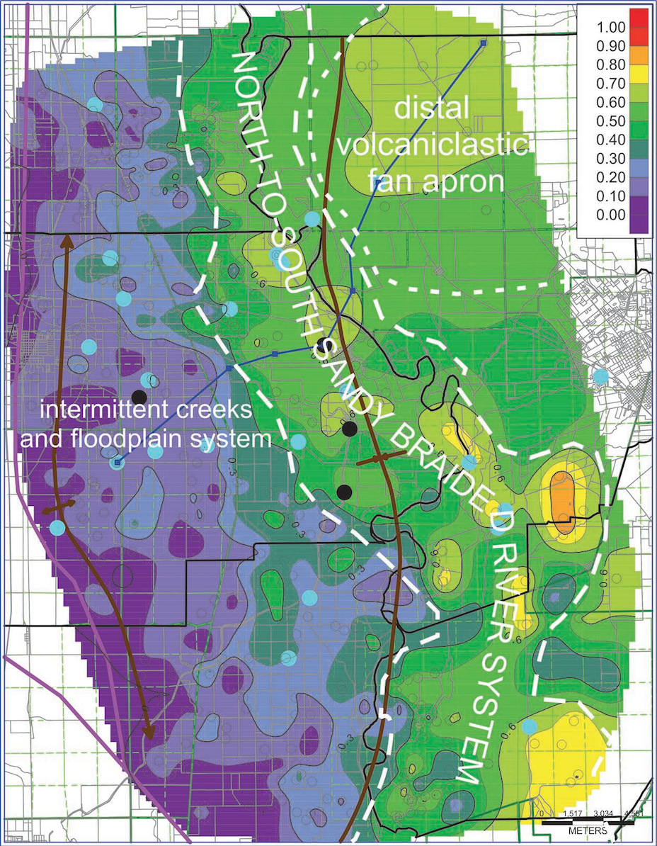
Figure 1: The map shows the fraction of water-bearing sands within the main lower Tuscan/Tehama formation interval. The colors span values from 0 to 1; 1 = 100% water-bearing sands, and 0 = 0% water-bearing sands). Note the general meandering river-like pattern of the high proportion of water-bearing sands (warm colors) in the eastern area. This pattern has a sharp boundary against the area with lower proportions of water-bearing sands (cold colors) in the western portion of the study area. The white lines and text represent the interpretation for how the original sands and muds were deposited approximately two to three million years ago in the northern Sacramento Valley.