
Our Office
BCCER
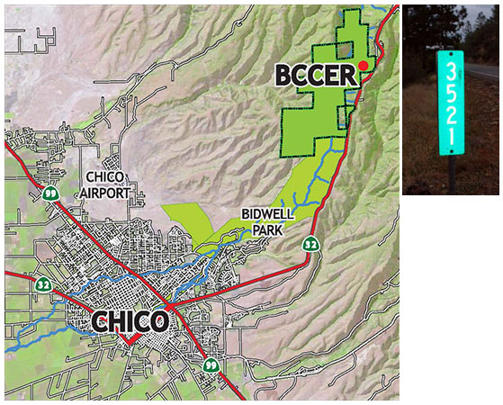
3521 14 Mile House Road
Forest Ranch, CA 95942
530-898-5010
530-898-5011
Mailing Address
BCCER/Chico State Enterprises
25 Main St. Suite 203
Chico, CA 95928-5388


Directions to BCCER Headquarters
BCCER on Google Maps:https://g.page/BCCER?share(opens in new window)
From Chico:
- From the Bruce Road/Highway 32 intersection take Highway 32 east 9.7 miles.
- Turn left at the green 3521 sign onto a paved, single-lane road.
- Follow the road to the parking area by the upper gate or continue the half mile to the Headquarters if you have permission to park there.
- The last road before the Reserve entrance is Crown Point, a mile before the turnoff.
- If you miss the 3521 sign, you will see the 14 Mile House Road subdivision and its historical marker on the right and will need to turn around.
From Forest Ranch:
- From the Nopel Avenue intersection in Forest Ranch, take Highway 32 west towards Chico 2.4 miles.
- Turn right at the green 3521 sign onto a paved, single-lane road
- Follow the road to the parking area by the upper gate or continue the half mile to the Headquarters if you have permission to park there.
- The 14 Mile House Road subdivision and its historical marker are on the left just before the Reserve.
Headquarters Office and Gate Access
If you have been given permission to proceed to the Headquarters Office, continue to where the road becomes gravel, travel 0.5 miles further to the Reserve headquarters office. Where the road forks keep right and continue down to park by the barn.
If you have not been given permission to proceed to the Headquarters Office, stop and park here by the gate.
The reserve gate is normally locked unless there is an organized event or tour. When you request access through our Reserves Access Management system (RAMs) you will receive a response and additional access information.